The Vanua Geographic Information System (GIS) is going to change the way we access information and will boost the quality of our strategic planning and decision‑making.
While launching the GIS system, Minister for Tourism, Lands and Mineral Resources Faiyaz Koya says the Vanua GIS is the first of its kind in Fiji – integrating datasets from different organisations such as the Fijian Elections Office and bringing it all together in one place – one platform.
He says it is a tool that was long overdue because data sharing has been one of the biggest challenges in Fiji.
Koya says this tool would make a difference in the area of disaster preparedness and the Fijian Government was able to use the GIS technology after Cyclone Winston to track relief assistance at the National Disaster Management Office.
He says they have been able to map those coastal communities that are most vulnerable to rising sea levels and start planning for their relocation.
Koya says all information can be assembled digitally in one web portal and accessed by authorized users with the click of a button.

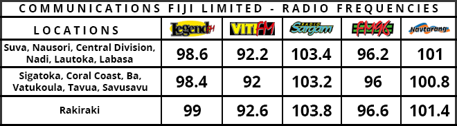
Stay tuned for the latest news on our radio stations