Conditions are intensifying across the south-east Queensland and northern NSW coast, with the Bureau of Meteorology warning Tropical Cyclone Alfred's slow track will bring a "very high risk of significant impacts".
The "slow moving" category two system is now expected to make landfall north of Brisbane either late tonight or early tomorrow morning, with the current warning zone extending from Double Island point to Grafton.
It's now 195 kilometres east of Brisbane and 180 kilometres east north-east of the Gold Coast.
Bureau of Meteorology (BOM) senior forecaster Christie Johnson said the conditions of a short thunderstorm could potentially last "six hours or more".
"It looks like it will initially make landfall on Moreton Island in the very earlier hours of tomorrow morning, or close to midnight, and then move across the mainland coast through the early hours of tomorrow," she says.
"We will feel the effects well and truly before it makes landfall."
More than 24,000 customers have lost power on the Gold Coast, 2,000 in Redland and 1,000 in the Scenic Rim. Several hundred people on the Sunshine Coast are also without power.
In northern New South Wales, more than 35,000 homes and businesses have lost power.
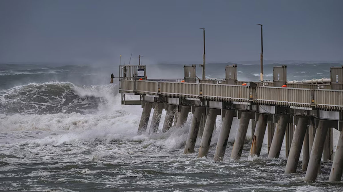
Damaging wind gusts of up to 120 kilometres per hour are already developing along the coast, with daily rainfall totals of up to 400 millimetres possible today and tomorrow.
Queensland Premier David Crisafulli said gusts of about 100 kilometres and hour had been recorded at Coolangatta on the Gold Coast overnight.
"The bureau is telling us that increasingly we'll start to feel those wind speeds, even in the likes of Brisbane and the Sunshine Coast," he said.
"And then there's that rainfall issue as well — it's a large system and the prospect of a lot rain over the next few days is a challenge."
Public transport services and elective surgeries are still suspended, but emergency departments are still open, with some health workers "preparing to sleep at the hospital to continue to service our community", Mr Crisafulli said.
"We'll do everything we can to get those key services back online after the system goes through," he said.
He chastised the "handful of idiots" who had ventured into the ocean, including a person who had to be rescued from a jet ski after ignoring warnings.
Residents in low lying areas in the Northern Rivers of NSW, including parts of Lismore and coastal areas such as Fingal Head, were told to evacuate by 9pm last night, while parts of Macksville, North Macksville, North Gumma and Bowraville have until 8am today.
On Friday morning, the Gold Coast council issued a cyclone Watch and Act Alert, telling people to stay inside for their safety as conditions intensify.
Refuge and evacuation centres have been set up throughout the regions in Tropical Cyclone Alfred's path.
There's a possibility Alfred could cross the coast as a category 1 system if winds weaken.
"The category only relates to the wind speed in that crossing, it doesn't relate to any thing such as the surf or the rainfall," senior BOM forecaster Jonathan Howe said.
"Regardless of the category it will be extremely dangerous."
Many supermarkets in Queensland and northern NSW have closed, while more than 600 schools in south-east Queensland and more than 280 in northern NSW are shut.
It will be the first cyclone to hit Brisbane in 50 years, with many on edge about what the system will bring.
Deputy Mayor of Brisbane Fiona Cunningham said the impact would likely be two-pronged.
"Brisbane is used to flooding but not cyclones, so we're talking about two different types of flooding in Brisbane," she said "We will get that storm surge, then we will get a lot of rain that's dumped in the city, and remembering 2022, we know what kind of impact that could have on our city."
Bracing for highest tide of the year
Massive swells are continuing to smash the south-east Queensland and northern NSW coastline, with the largest swell ever recorded off Main Beach on the Gold Coast rolling through at 12.3 metres on Thursday.
The power of Tropical Cyclone Alfred is pushing tides higher and higher as it moves closer to the coastline.
Original Story link : https://www.abc.net.au/news/2025-03-07/tropical-cyclone-alfred-queensland-nsw-landfall-impacts/105016930

Stay tuned for the latest news on our radio stations