People are advised to take the necessary precautions as a Tropical Cyclone Alert is now in force for Viti Levu, Yasawa, Mamanuca Group, Kadavu and nearby small islands, Lomaiviti and the Southern Lau Group.
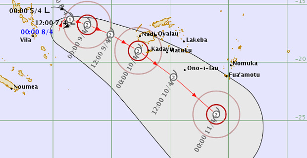
The Nadi Weather Office says the Tropical Depression was located about 770km West of Nadi at 3pm today.
The Weather Office says the system is expected to track South East wards late this evening after looping and is expected to further intensify into a Category 1 Tropical Cyclone within the next 12 to 18 hours.
The Weather Office says the environmental condition remains favorable for further intensification and the system is likely to pass just southwest Fiji on Tuesday or early hours of Wednesday.
They say that the outer active rain bands from the Depression have started to affect the western parts which are from Sigatoka to Rakiraki.
As the system moves closer to Fiji, rain will become heavy and frequent from tomorrow.
Nadi Weather Office Director Ravind Kumar says as the system moves South East wards towards Fiji, it is expected to track close to land areas and it has the potential to further intensify to a Category 2 or Category 3 Tropical Cyclone because of favorable environmental conditions for further intensification.
Forecasters say Tropical Cyclones have behaved erratically, when encountering land masses, thus the possibility of making a landfall cannot be ruled out at this stage and therefore, the expected system poses direct threat to Fiji at this stage.
They say they will closely monitor this, and alerts and warnings will be updated accordingly.
Forecasters say that if the depression continues to intensify and stays on the current track then it may bring damaging winds with speed of 62 to 85 kilometres per hour over the Western Division by late tomorrow afternoon and early Tuesday over Kadavu and nearby smaller islands and the rest of Viti Levu, Lomaiviti and Southern Lau Group.
A strong wind warning remains in force for all land areas and waters of Fiji.
People can expect strong winds from tonight.
People in Viti Levu, Yasawa and Mamanuca Group, Kadavu and nearby small islands, Lomaiviti and Southern Lau Group can expect winds with average speeds of 35 to 55 kilometres per hour with momentary gusts to 80 kilometres per hour.
The Weather Office says that people in Viti Levu, Yasawa and Mamanuca Group, Kadavu and nearby small islands, Lomaiviti and Southern Lau Group can expect periods of heavy rain, thunderstorms, flooding of low lying areas including sea‑flooding of low lying coastal areas.
For Vanua Levu, Taveuni and nearby smaller islands and the Northern Lau Group, strong winds with average speeds of 35 to 50 kilometres per hour with momentary gusts to 80 kilometres per hour.
People in these areas can expect periods of heavy rain, thunderstorms and flooding.
For Kadavu, strong wind warning and periods of heavy rain, thunderstorm, flooding of low lying areas and sea flooding is expected.
These expected strong winds will be able to bring down some temporary or loose shelters and also damage crops.
For the rest of Fiji, periods of heavy rain, thunderstorm over most places.
Please note that with more rain forecast and soil being saturated, there is high risk of severe river flooding especially in the Western Division. The approaching system has the potential to produce more than 120mm of rainfall in 24 hours this weekend.
As the system moves closer to the Group, expect periods of heavy rain and thunderstorms with rough to very rough seas in the weekend and could even increase to high seas.
Damaging heavy swells is also expected with high risk of severe river flooding.
The Weather Office also says that there is also chances of land slides.
People living in flood prone and low lying areas are reminded to take all necessary precautions and remain alert and to keep listening to us for latest weather updates.

Stay tuned for the latest news on our radio stations