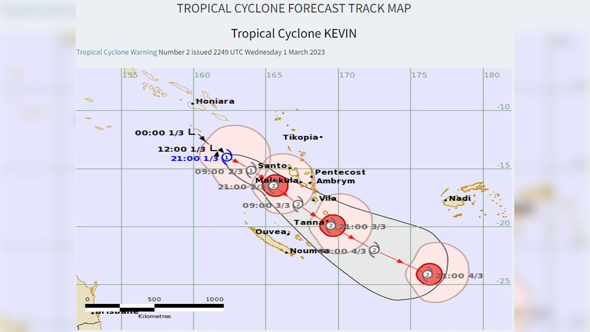
As Tropical Cyclone Kevin forms near Vanuatu, a Heavy Rain Alert has been issued for the Northern parts of Ba and Ra, greater Nadi, Lautoka and Ba area, interior of Ba and Nadroga-Navosa, Sigatoka, Kadavu and nearby smaller islands, Yasawa and Mamanuca groups, Lau and Lomaiviti groups.
A Strong Wind Warning remains in force for the land areas of Nadi, Lautoka and Ba, Yasawa and Mamanuca groups.
Tropical Depression 09F (TD09F) has intensified into a category 1 tropical cyclone and named Kevin earlier today while located about 480 kilometres westnorthwest off Santo.
TC Kevin is currently moving southeast at about 7 kilometres per hour and is expected to lie very close to Santo, about 200 kilometres west-southwest at 6am tomorrow.
TC Kevin is rapidly intensifying with possibility of it developing further into a category 2 system.
Heavy rain and damaging gale force winds associated with TC Kevin is expected to start affecting the northern parts of Vanuatu including Santo and Malekula from tonight and spreading to the rest of Vanuatu from tomorrow.
As TC Kevin moves south, to the far southwest of Fiji, parts of the group especially the land areas of Yasawa and Mamanuca groups, Nadi, Lautoka and Ba is expected to experience strong winds with speeds of 45 kilometres per hour and gusts up to 80 kilometres per hour from tonight.
Winds of this strength can break tree branches, damage crops and weak, unshielded structures like temporary sheds and tents in exposed communities.
Heavy rain is expected from today especially over Yasawa and Mamanuca groups, Northern parts of Ra, greater Nadi, Lautoka and Ba area, interior of Ba and Nadroga-Navosa, Sigatoka, Kadavu and nearby smaller islands, Lau and Lomaiviti groups.
Flood prone areas in the Western and Northern parts of Viti Levu, especially Rakiraki, Tavua, Ba and others may once more be at risk of flooding.
There will also be an elevated risk of flash flooding over the weekend and into early next week.
From Saturday, damaging heavy swells with wave heights of 4 to 5 metres is expected over Fiji waters, thus, there’s existing risk of coastal inundation over the coastal areas of Bua and Macuata, Yasawa and Mamanuca groups, Western Division, Coral Coast, Beqa, Vatulele, Kadavu and Ono-i-Lau.
Hazardous breaking waves, strong currents are risky for swimming, fishing and other recreational sea activities. Sea conditions can also be dangerous especially for small boats as it can capsize due to large waves and rough seas.
Unsettled weather is expected to continue into early next week.
Meanwhile Category 4 tropical cyclone Judy is currently moving away from Vanuatu.
At 6am today, TC Judy was located about 200 kilometres east-southeast off Aneityum or about 290 kilometres southeast off Tanna.
Stay tuned for the latest news on our radio stations


