A heavy rain alert remains in force for Fiji.
Gale force winds may cause loose objects to fly, break twigs and tree branches and slight damages to weak-structured houses.
The Weather Office also says the concern also extends to coastal inundation including sea flooding of coastal areas.
Weather forecasters say other parts of Fiji can be affected as TC Harold moves closer.
It is therefore advisable that we prepare accordingly.
Take the necessary steps to ensure that homes and properties are well secured. Ensure that your compounds are cleared of all debris that could harm individuals and damage properties in the event of strong winds.
For those who live along low-lying flood prone areas, please be aware of your escape routes in the event of rising flood waters.
Cyclone Harold made landfall on the island of Espiritu Santo in Vanuatu earlier yesterday.

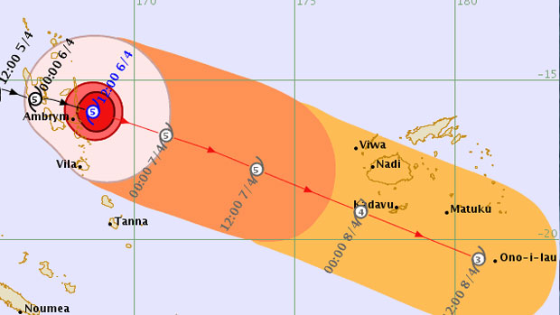
TC Harold threat map 18 issued at 1:27 am Tuesday, in Fiji 07/04/2020
Observations and reports received from Vanuatu indicate damages to infrastructure, heavy rain and flooding of low lying areas.
Severe Tropical Cyclone Harold was analysed at about 950km West North-west of Nadi at 12 this morning.
It is a Category 5 system with sustained winds of approximately 215km per hour close to its centre and momentary gusts extending to 295km per hour. It is moving east-south-eastward at about 19kmper hour.
Based on the current projection the centre of the cyclone is expected to be located at about 690km West of Nadi at midday today and about 380km West of Nadi at midnight tonight.
At midday tomorrow, it is expected to be located approximately 310km south-southwest of Yasawa-I-Rara or about 200km south-southwest of Nadi. As it continues to move in that direction, it is expected to pass just towards the southwest of Fiji.
Stay tuned for the latest news on our radio stations


