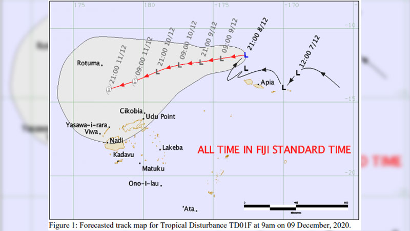
The tropical low that is located near Samoa has intensified and upgraded to a tropical disturbance (TD01F), and is expected to intensify to a tropical depression and then a cyclone however based on current projections the system is expected to pass far North of Fiji.
The Nadi Weather Office says the system is located about 905 kilometres North East of Vanuabalavu, Lau.
Tropical disturbance TD01F is moving west towards Rotuma at about 18 kilometres per hour and is expected to intensify further into a tropical depression in the next 12 to 24 hours and possibly named a tropical cyclone by later Friday. By then the system is expected to be located about 280 kilometers East South East of Rotuma.
The other tropical low remains weak and slow moving near Rotuma.

This system will bring about heavy rain and strong winds over land areas and waters of Rotuma from later tomorrow and will be enhanced by the approaching TD01F.
Expect strong winds over the land areas of Vanua Levu, Taveuni and nearby smaller islands, North Eastern parts of Viti Levu from Tailevu to Rakiraki, Coral Coast to Pacific Harbour, Lau, Lomaiviti, Yasawa, Mamanuca, Kadavu, Vatulele and Beqa. These winds are not destructive but could be dangerous for those navigating Fiji waters.
Members of the public are advised to remain alert and vigilant.
The Weather Office says the current situation is closely monitored and any alert and warning will be issued as and when significant changes are anticipated.
Stay tuned for the latest news on our radio stations


