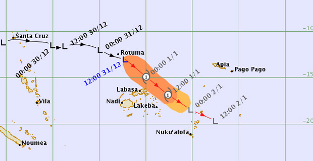
A gale force warning remains in force for Cikobia, Eastern Vanua Levu from Lagalaga, Udu Point, Saqani, Natewa to Karoko, Rabi, Taveuni, Qamea, Laucala Islands and Northern Lau group.
A strong wind warning remains in force for Vanua Levu, Lomaiviti group, Northern Viti Levu from Ba, Rakiraki to Tailevu North, and the Yasawa Group.
A heavy rain warning remains in force Taveuni and nearby smaller islands and Northern Lau group.
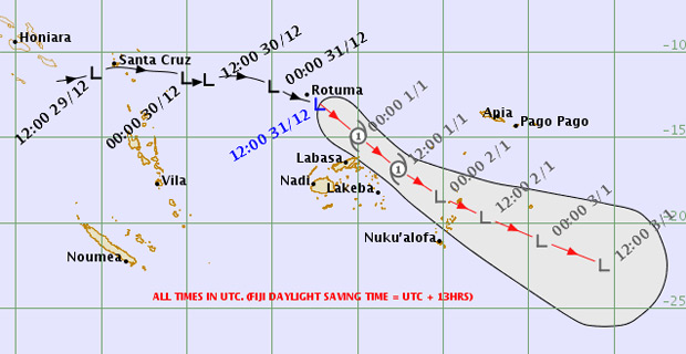
TDO3F-Threat-Track-Map as of 08:39am 1st-Jan-2019 [Photo: met.gov.fj]
Flooding of low lying areas is also possible.
The Nadi Weather Office says the Tropical Depression was located at about 150km North Northwest of Udu Point and about 190km North of Labasa at 10am today.
They say the depression may intensify into a Category 1 Tropical Cyclone in the next 6-9 hours, with average winds of 65km/hr and momentary gusts to 90km/hr close to the centre.
They say the depression is moving east-southeast at about 25km/hr and on the projected path it is expected to be located about 190km Northeast Lakeba or about 201km East Northeast of Udu Point at 10pm today.
The Weather Office says on its anticipated development and track, the system may bring damaging gale force winds for Cikobia, Eastern Vanua Levu from Lagalaga, Udu Point, Saqani, Natewa to Karoko, Rabi, Taveuni, Qamea, Laucala Island and the Northern Lau group from later.

Stay tuned for the latest news on our radio stations