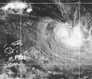
The Nadi Weather Office has confirmed this hour that the Tropical Depression currently located to the South of Samoa and far East of Fiji, may develop into a cyclone and continue to head towards Fiji.
Please note this is based on current analysis after the assessment of the models by the Weather Office.
Weather Office Forecaster, Stephen Meke says based on their assessment, there is a possibility that the depression which is currently located 740 kilometres East North East of Vanuabalavu will develop into a cyclone within the next 12 to 24 hours.
Meke says based on their assessment, the people of the country need to prepare for the possibility of a category 2 or 3 cyclone to come towards Fiji by Thursday.
He says the system is expected to come with a lot of heavy rain and destructive winds.
If it does happen then it is expected to affect many parts of the country.
Meke says people should prepare for the worst and it would be good news if the system weakens or moves away.
However he says the models are suggesting that it will intensify.
A category 2 cyclone can cause significant damage to signs and trees, and heavy damage to some crops.
There can be a risk of power failure.
Small craft may break moorings.
A category 2 cyclone's strongest winds are destructive winds with typical gusts over open flat land of 125 to 164 kilometres per hour.
A category 3 cyclone can cause roof and structural damage.
Power failures are likely.
A category 3 cyclone's strongest winds are very destructive winds with typical gusts over open flat land of 165 to 224 kilometres per hour.
Stay tuned for the latest news on our radio stations

