People are advised to be prepared for strong winds and heavy rain as the centre of Severe Tropical Cyclone Gita is expected to enter the Fiji waters over the Southern Lau Group tomorrow.
The Fiji Weather Office says this is based on the current projected path of Cyclone Gita.
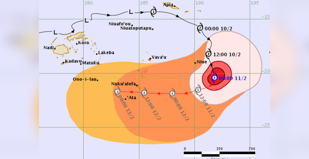
Weather Office Director, Ravin Kumar confirms that on the projected track, Cyclone Gita is anticipated to affect Southern Tonga and may enter Fiji waters tonight and pass South of Ono-i-Lau as a Category 4 system tomorrow night.
Kumar says that before it approaches strong winds can possibly expand to the whole of Fiji while damaging gale force to strong force winds can expand over the Western and Southern parts of Fiji as it comes closer.
Although the centre of the cyclone will not pass over Viti Levu, people are expected to experience strong winds and heavy rain.
Kumar says that the Weather Office will continue to monitor the system as it comes closer and as new information comes on hand the projected tracks will be adjusted.
A Tropical Cyclone Alert remains in force for Southern Lau Group and is now in force for Kadavu and nearby smaller islands.
Cyclone Gita was located about 910km East of Ono-i-Lau and 1265km East-Southeast of Kadavu.
The Weather Office says that close to its centre, the cyclone is expected to have average winds of up to 165km/hr with momentary gusts to 230km/hr.
It says that the cyclone is moving West Southwest at about 19km/hr adding that on this track the cyclone centre is expected to be located at about 680km East of Ono-i-Lau or about 1045km East-Southeast of Kadavu at 12pm today.
The Weather Office says Severe Tropical Cyclone Gita may bring damaging gale force winds over the Southern Lau group, Kadavu and nearby smaller islands from tomorrow morning.
For the rest of Fiji, expect moderate southerly winds becoming gusty from tomorrow night and winds may increase to strong with an average speed of 50km/hr and momentary gusts to 70km/hr.

Stay tuned for the latest news on our radio stations