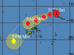
An alert has now been issued for Vanua Levu, Taveuni, Northern Viti Levu, Yasawa, Mamanuca and nearby smaller islands including the Northern Lau group as Tropical Cyclone Evan continues to intensify.
As of 10am today, Tropical Cyclone Evan which is now a category 4 was located at 745 kilometers East North East of Udu Point and 825 kilometers East North East of Labasa.
A strong wind warning and damaging heavy swells warning is also now in force for Vanua Levu, Taveuni and nearby smaller islands including the Northern Lau group.
Close to it's center, the cyclone is expected to have average winds up to 165 kilometers per hour with momentary gusts to 230 kilometers.
On this projected trend, tropical Cyclone Evan is expected to bring gale force winds over Vanua Levu, Taveuni and nearby smaller islands including the Northern Lau group by tomorrow afternoon and Yasawa, Mamanuca and Northen Vitilevu by early Monday morning.
Rain will become frequent and heavy with squally thunderstorms from tomorrow evening with damaging heavy swells.
Sea flooding of low lying coastal area is also expected.
Nadi Weather Office Duty Forecaster, Amit Singh said people should take precautions as Tropical Cyclone Evan continues to intensify and is highly likely to enter the Fiji waters by late tomorrow afternoon.
A category 4 cyclone has very destructive winds between 159 to 200 kilometers per hour and the effects from this can include significant roofing loss, structural damages and widespread power failure.
Meanwhile for the rest of the Fiji group, rain and thunderstorms are expected to start with moderate to fresh South East winds becoming strong with average speed of 55 kilometers per hour and momentary gusts to 85 kilometers per hour from tomorrow.
Fijivillage advises people to take all the necessary precautions - secure your homes, store water and food, buy batteries, torches and ensure you have a transistor radio to listen to the weather bulletins.
Stay with Fijivillage for continuous updates.
Story by: Praneeta Prakash