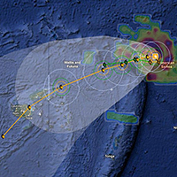
People have been urged to take precautions as Tropical Cyclone Evan continues to intensify and is highly likely to enter the Fiji waters by late tomorrow.
According to Nadi Weather Officer Forecaster, Amit Singh, Tropical Cyclone Evan which is now a category 4 was located at 800 kilometers East North East of Udu Point and 880 kilometers East North East of Labasa at 4am this morning.
A category 4 cyclone has very destructive winds between 159 to 200 kilometers per hour and the effects from this can include significant roofing loss, structural damages and widespread power failure.
Singh added that though there are changes in the forecasted trend people still need to be prepared.
An alert has been issued for Vanua Levu, Taveuni and nearby smaller islands including the Northern Lau group.
A strong wind warning and damaging heavy swells warning is also now in force for Vanua Levu, Taveuni and nearby smaller islands including the Northern Lau group.
Close to it's center, the cyclone is expected to have average winds up to 165 kilometers per hour with momentary gust to 230 kilometers.
On this forecasted trend, tropical Cyclone Evan is expected to bring gale force winds over Vanua Levu, Taveuni and nearby smaller islands including the Northern Lau group by tomorrow afternoon.
Rain will become frequent and heavy with squarely thunderstorm from this evening with damaging heavy swells.
Sea flooding of low lying coastal area is also expected.
Stay with Fijivillage for continuous updates.
Story by: Praneeta Prakash